
Hikers Log - trail date: day 51
(Lickskillet Hollow (mile 605) - Wapiti Shelter (mile 618.2))
After a pancake breakfast, AC and I left our Airbnb yurt in West Virginia, stopped at the Cathedral Café for lunch, and got back to trail head around 1:45pm. We sat in the tailgate of her Subaru Crosstrek while I finished the cassoulet and baklava ice cream that we had prepared yesterday. It was delicious! Many hikers walked past while we sat at the trailhead including Dr. Cheese, Calypso, Maverick (an older gentleman I met in the Smokies), Meatsuit, and Cap'n. A couple of them mistook AC’s car for trail magic, which was probably a bit disappointing for them😂 AC and I both agreed that it would be fun to do trail magic in the future.
After a tough "see ya later," I got hiking around 2:30pm. Despite my late start, I wanted to make it as far as possible. The ambitious part of me thought that Wapiti Shelter, 13.2 miles ahead, should be my goal. I made it about half a mile and had to dig an emergency cathole. Afterwards, I met a thru-hiker named "Zero" from Macon GA. Zero got his trail name because he has not taken any zero days yet, which is impressive, considering we’ve hiked over 600 miles (and I’ve already taken four zeros). He has worked in commercial contracting and started his thru-hike almost two weeks after I did. I enjoyed chatting with Zero, and we ended up mostly hiking together for the next 4 miles.
During this time, I was stoked to spot my first rat snake on trail! It was hard to miss, stretched out perpendicular across the trail like a black hose. The day was hot, so I’m sure the snake was enjoying the afternoon sun. As I approached to get photos, the snake rustled the tip of its tail in the leaves in an effort to imitate a rattlesnake. When this display failed to put an end to the photo session, the rat snake opted to slowly slither away.
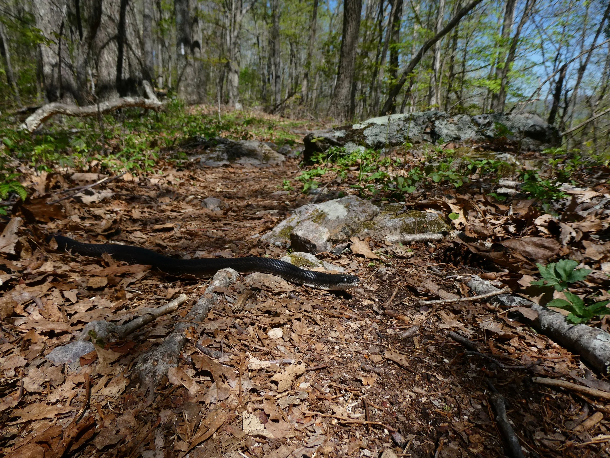
This is the first rat snake I have encountered on trail!
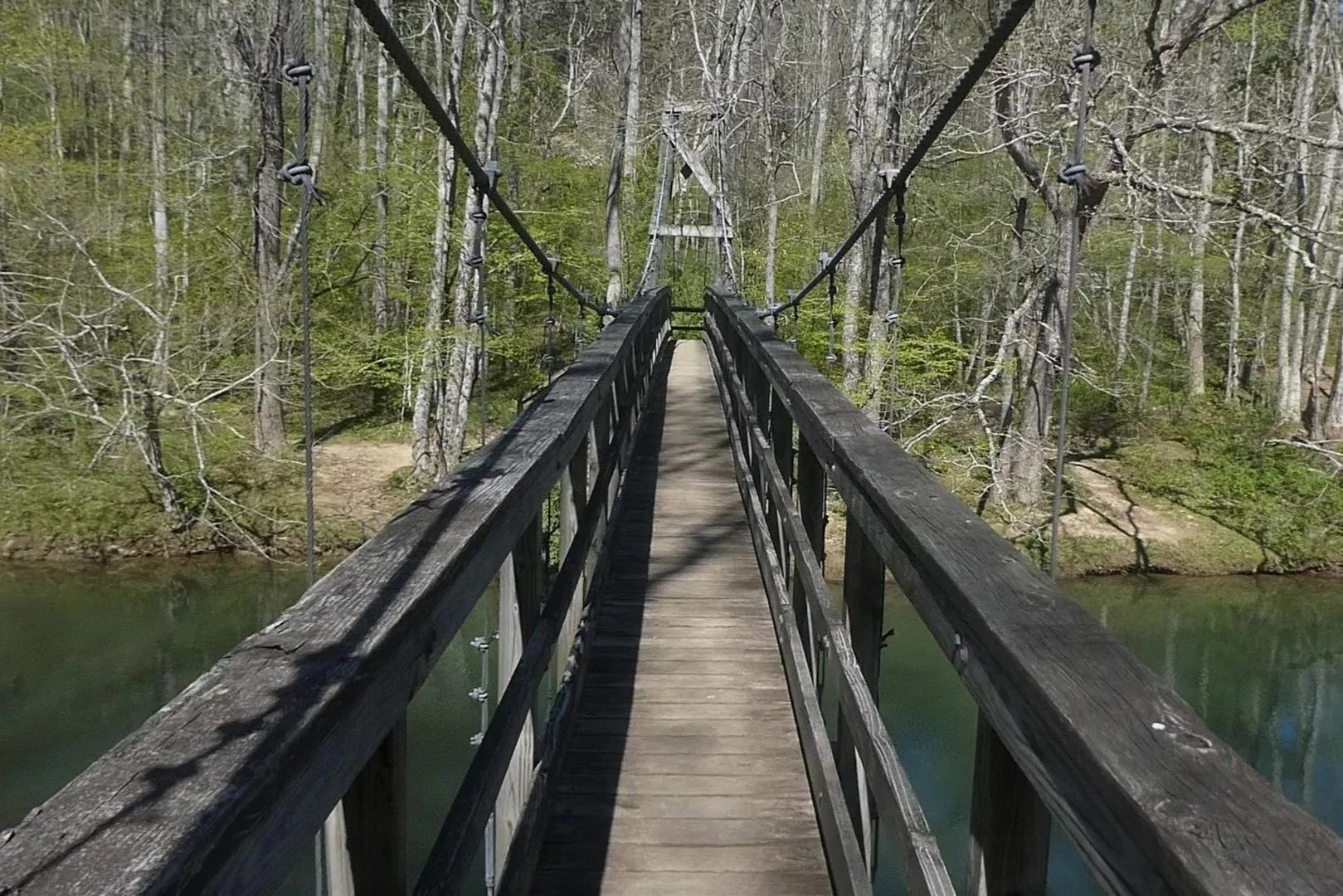
Crossing a large, narrow swinging suspension bridge over Kimberling Creek

This bridge was huge!

Zero and I crossed a very impressive swinging suspension bridge over Kimberling Creek, which might be the coolest footbridge I’ve crossed on trail. Afterwards, I stopped to collect water and Zero hiked on. I hiked another 2 miles, dropped my pack, and took the 0.3 mile side trail to Dismal Falls, which was a nice spot.

Dismal Falls is found at the end of a 0.3 mile side trail off the AT
The trail followed Dismal Creek for the next 7 miles. Hiking near water is always convenient because it means I don’t need to carry much. I quickly lost count of the number of small bridges and stream crossings. Much of this section was dominated by dense tunnels of rhododendron, but there was also a short stretch in a beautiful pine forest. The golden hour light bathed the trees in a warm glow and I spotted a group of deer prancing through the undergrowth. I saw deer two days ago on my road walk to Lickskillet Hostel, but these were my first deer spotted while hiking on trail, and I was again struck by how big they looked.
As I hiked, I spent a lot of time considering my resupply options. The next resupply spot is Pearisburg, which I’ll reach tomorrow. After that, the next major grocery store is Daleville, which is at mile 730.3. That’s 112.1 miles from where I plan to camp tonight. Between Pearisburg and Daleville is a potential gas station resupply. So, I really need to figure out how many days it’s going to take for me to get from Pearisburg to Daleville. I resupplied with AC, so right now, I’ve got four full days worth of food, plus a dinner for tonight. That makes the timing of hitting Pearisburg tomorrow a little awkward. I think probably the best approach will be to stop in Pearisburg to grab things I can’t get at the gas station resupply (e.g avocados), since I can probably find most basics at the gas station (e.g. ramen). I need to sit down tonight and take an inventory of my food, consider the mileage, think about how many days it will take, and figure out what exactly I need to pick up in Pearisburg. This will be the hardest I’ve had to think about a resupply😅 I might find that I just need one or two non-essential items. If so, I could skip Pearisburg altogether and roll the dice on a gas station resupply. Making a few substitutions won’t be a big deal. That’s just how it is sometimes.
About 6 miles past Dismal Falls, I reached a small pond just before Wapiti Shelter. I stopped briefly to watch the fish swimming in the shallows, and then made my way to the shelter at just about 7pm.

A trail crew appeared to be renovating the shelter. Logs and lumber were strewn around the campsite in a haphazard manner. I set up my tent and then backtracked a bit to soak my feet in Dismal Creek. The water was painfully cold, but afterwards my feet felt rejuvenated. I made my way back to the shelter and met two older gentlemen named “Doc” and “Chief.” Doc is a retired state veterinarian from Virginia who thru-hiked in 1975. He showed me a tattoo on his calf, which had ‘75 imbedded in the AT logo. Doc was an abundantly cool dude. I asked him about how the trail had changed since 1975 and he explained that there used to be a lot fewer bridges. A thru-hike in 1975 involved regularly wet feet.
Oh, and apparently this shelter is known as “the murder shelter.” Doc explained that a man from Pearisburg murdered two hikers here at Wapiti Shelter in 1981. I later learned that the man’s name was Randall Lee Smith. He served 15 years for the murders, and then was released on a 10-year probation despite outrage from locals and the hiking community. In 2008, he disappeared from his home and was found and then attempted to kill two fishermen in 2008. He died after stealing and crashing one of the fisherman’s’ truck. Spooky👻
I found some ramps and added them to my ramen before hanging a bear bag and retiring for the evening.
Foraging wild leeks for a gourmet ramen bomb four Michelin stars

Wapiti Shelter featuring "Doc" (standing), a retired state veterinarian from Virginia who thru-hiked in 1975